Using your GPS for routing
One of the most useful features of GPS units is its ability to display a route from your starting point to your destination. The latest units give you turn-by-turn directions with many even "speaking" the directions. Route planning allows you to spend time considering how you want to get to your destination if the shortest or quickest way is not the goal. For many motorcycle rides, how you get there is just as important as arriving.
Routes in real time
The simplest way to create a route for most GPS units is to enter a destination address and let the unit determine the "best" route automatically. Most GPS units use a version of Dijkstra's algorithm for finding the shortest path from one point to another. I generally use the built-in routing function when I need to quickly get from point A to point B without much regard to how I get there. For most of my motorcycle trips, the calculated "best" route is generally not the route I want to take.
Routes using software that came with your unit
When you want to travel a specific route, for example along a scenic highway or to stay off the interstate, you need to manually create the route. Generally, the easiest way to do this is to use the software that comes with your GPS unit. Basically, you will put the mapping program into "route mode", then click points along your desired route from start to destination. The specific steps will depend on your particular mapping program. When finished, connect your GPS unit to your computer (typically via USB), and click the transfer button to download the route to your unit. When you're ready to navigate, choose this downloaded route in lieu of letting the unit calculate a route.
Routes using the web
If you've been reading this blog, you know I suffered a computer crash that turned out to be more serious than a dead hard drive. This computer was a Windows XP machine so software like Garmin's MapSource and a myriad of other applications for mapping worked without a hitch. I haven't personally done extensive research, but based on information from various podcasts and web sites, it appears most GPS manufactures only provide Windows compatible software.
Presently, I'm conducting an experiment to see if I can function with minimal aggravation using a Mac running OS X. A self imposed restriction in this experiment is to avoid purchasing software. This has directed my focus to the web, and so far, I've had interesting results. As I become more experienced in the various tools, I will provide updates through subsequent blog postings.
Apple MacBook Pro MA896LL/A 15" Notebook PC (2.4 GHz Intel Core 2 Duo, 2 GB RAM, 160 GB Hard Drive, DVD/CD SuperDrive)
An aside:
Bookmark GPS Visualizer. There's much info here that I haven't fully digested. It's likely that most of what you want to do with a GPS can be done from this web site.
My Garmin Zumo ingests route, waypoint, and tracking data in GPX format. (This is interesting since Garmin has its own proprietary data format.) So, I investigated web services that output route data using GPX.
I very much like Google maps. It is easy to enter a starting point and a destination and have Google maps determine a route. You can click the 'Avoid highways' option which keeps the route off of the interstate. Further, you can click and drag the route to other roads or intervening destinations if desired. In short, you can easily create a custom route from start to destination. Google maps also provide turn-by-turn directions and calculate the overall mileage and estimate the travel time. Because of its ease of use, Google maps is an integral part of my motorcycle trips planning.
So, an ideal, no cost solution for my Mac is to have some utility that will take the Google maps route data and output a GPX formatted file. Kudos to the author of the Communications From Elsewhere blog who has created a Google maps to GPX converter.
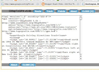
To use it, you need to bookmark the GMapToGPX 'bookmarklet' found at the site. Then go to Google maps and create your route. Click the bookmarklet. A new page is generated with the route data in GPX format ready for cut & paste into any text editor. Transfer this file to your GPS unit and you're good to go. I've found that clicking each option button so they read "Route Track Points" provides me with the best output for my GPS unit. Experiment to see what works best for you. Note, there's no reason you can't use this with your Windows or Linux based computer.
An example of directions provided by Google maps from Washington DC to Manhattan:
View Larger Map
After a couple of drag & drops, a more scenic route along the east coast:
View Larger Map
Here's what the GMapToGPX bookmarklet provides when clicked. Cut the text from the window and paste into any text editor. Save as a plain text file. Then transfer it to your GPS unit.

Good luck!
Post comments if you find this useful.
No comments:
Post a Comment