At a minimum, the simplest GPS units will give you the latitude & longitude of your current location. However, nearly any GPS unit you buy today will provide much more information including:
- your position overlaid on a map
- pre-planned routes (highlighted roads) to your destination
- "bread crumbs" or tracks (highlighted path) from your starting point
- your speed, distance, estimated time to destination
- and all manner of other data like average moving speed, average overall speed, time of sunrise, etc.
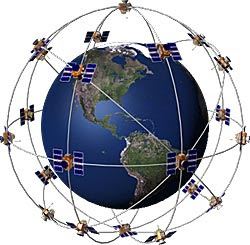
Determining position is computationally intense--today's GPS units are essentially small, hand-held computers--but conceptually simple. To determine position, the GPS unit measures the time it takes to receive the signal, which is traveling the speed of light, from at least two satellites. Triangulation of these two measurements provides your position on the ground. Using the timing data from a third satellite, the GPS unit can determine your altitude. Thus, with at least 3 satellites, your GPS unit can determine your 3-dimensional position anywhere on the planet.
The NAVSTAR GPS was intended for use by the US military. Since each satellite transmits its coded signal without regard to where it is pointing on the earth, anyone with a GPS receiver can collect it. To reduce its utility to nonmilitary receivers, an "error" component was incorporated in the coded signal that limited accuracy to about 300-ft for all except US military GPS units.
In 1983, President Reagan issued a directive that the NAVSTAR satellite signals could be freely used for civilian applications. The Federal Aviation Administration (FAA) embarked on an effort to employ GPS for use with commercial airlines and was working on an ingenious technique to markedly increase its accuracy. (Note the irony: 1 part of the US gov't was trying to circumvent the efforts of another part of the US gov't.) In 2000, President Clinton issued a directive that the error component of the GPS signal be shut off. Immediately, all existing GPS units were accurate to about 50-ft.
Since then, a technique known as differential GPS, DGPS, has been implemented which provides position accuracy down to about 12-ft. DGPS is used in all current commercial GPS units. Another technique known as wide area augmentation system (WAAS), based on the work of the FAA, provides accuracy down to less than 10-ft.
The number of GPS units available today is considerable. The FCC required all cell phones built since 2005 to have built in GPS so the phone can be located during an emergency 911 call. With GPS, these phones can have a multitude of other uses including cell phone tracking (keep track of the whereabouts of your child) to providing location based information like directions to a chosen destination. Currently, GPS units come in a myriad of shapes and sizes for use with all sorts of other equipment including portable hand held units, larger units to be mounted in vehicles, and others combined with computers and cameras.
The GPS unit I use for motorcycle rides is the Garmin Zumo 450. The Zumo GPS is specifically designed for use on motorcycles: it is waterproof, has large buttons and a touch screen for use with gloved hands, and hardened against vibration.
Garmin Zumo 450 Motorcycle GPS Navigator
The image below shows the track of several cross country motorcycle rides I've made in the last few years overlaid on Google Earth. In a subsequent post, I'll detail how to make these overlays.

No comments:
Post a Comment